Imagine a farmer who could fly over every acre of their land, equipped with eyes that see the hidden health of every single plant, and a hand that could deliver care with surgical precision. This is no longer a scene from science fiction. This is the reality of Agriculture 4.0, driven by the spectacular fusion of Drones and Artificial Intelligence (AI).
Instead of spending hours walking the fields for manual inspections, farmers can now monitor and manage their entire operation from the air. It’s a revolutionary shift, transforming the art of farming from guesswork to absolute precision.
At Dev Station, we are at the forefront of developing aerial agricultural analytics. This article will take you on a journey to explore how these “eyes and brains in the sky” are reshaping the future of farming.
1. The Challenge of a Ground-Level View: What the Naked Eye Misses
Managing a large-scale farm has always been a monumental task. Traditional manual monitoring has inherent limitations:
-
Time and Labor-Intensive: Walking the fields to inspect every zone is simply not feasible for large operations.
-
Missed Problems: The early signs of disease, nutrient deficiencies, or water stress are often invisible to the human eye. By the time we spot a problem, it’s often too late.
-
Wasted Resources: Blanket-spraying an entire field with pesticides or fertilizers is incredibly wasteful, driving up costs and harming the environment and healthy crops.
We need a new perspective—a view that is both comprehensive and deeply insightful. We need a view from above.

2. The Perfect Duo: How Drones and AI Work in Harmony
This is a seamless collaboration between hardware and software, between the “eyes” and the “brain.”
🚁 Step 1: Drones Gather Data – The Eyes in the Sky
These aren’t your standard hobbyist drones. Our agricultural drones are equipped with highly specialized cameras:
-
Multispectral Cameras: These sensors can “see” wavelengths of light that are invisible to the human eye. They capture data on how plants reflect light, which is used to generate critical health indexes like NDVI (Normalized Difference Vegetation Index). In simple terms, this index reveals whether a plant is healthy and thriving or stressed and struggling, using colors the naked eye cannot distinguish.
-
Thermal Cameras: These cameras detect variations in canopy temperature, which can be an early indicator that a plant is suffering from water stress or a developing infection.
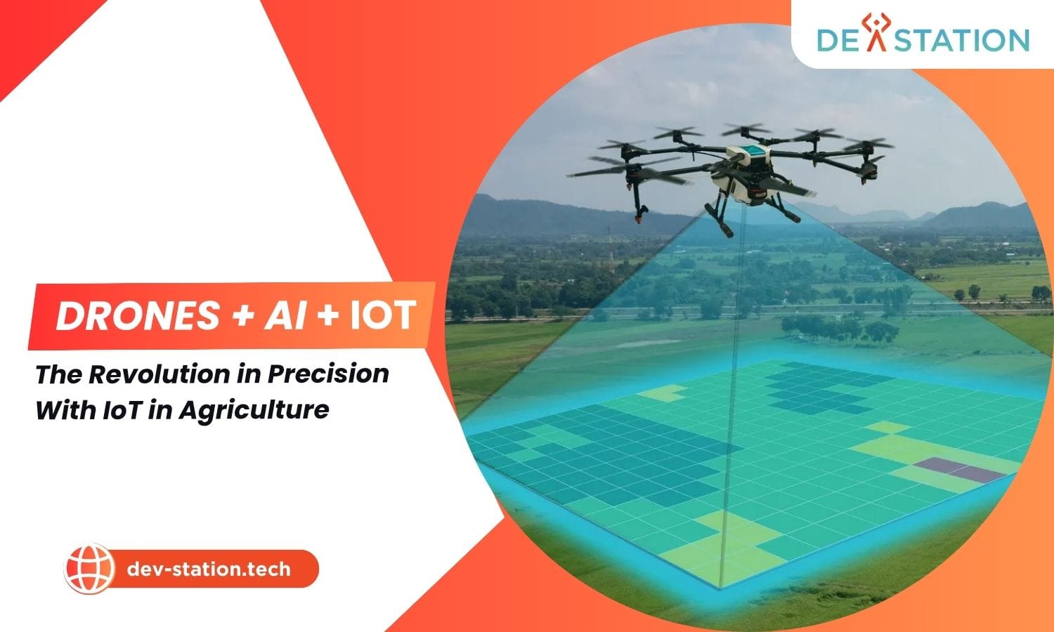
In a single, short flight, a drone can scan hundreds of acres, capturing thousands of high-resolution images to create a detailed digital twin of the entire farm.
🧠 Step 2: AI Analyzes the Data – The Intelligent Brain
Raw image data from a drone is meaningless without the power to interpret it. This is where Dev Station’s Artificial Intelligence comes in.
-
Image Processing: AI algorithms process and stitch together thousands of images, analyzing them pixel by pixel.
-
Problem Identification: The AI “brain” is trained to automatically detect specific issues:
-
Zones of stressed or nutrient-deficient crops.
-
Emerging disease or pest infestations.
-
Areas with high weed density.
-
Patches of land that are too dry or waterlogged.
-
-
Creating a “Health Map”: The final output is an intuitive, color-coded crop health map. Red zones might indicate weak plants needing immediate intervention, while green zones represent healthy areas.

3. From Analysis to Action: Precision Farming in Practice
A health map isn’t just for viewing; it’s a prescription for precise, cost-effective action.
🎯 Precision Spraying of Fertilizers and Pesticides
This is the application with the most immediate and significant economic benefit.
-
End Blanket Spraying: Instead of spraying an entire 100-acre field, the AI map might reveal that only 15 acres are actually affected.
-
Integrate with Smart Equipment: The data from the health map can be directly uploaded to GPS-enabled sprayers or sprayer drones. These machines will then autonomously target only the marked “red zones” with the exact dosage required.
-
The Result: You can save up to 40-60% on fertilizer and pesticide costs, while protecting the environment and the quality of your produce.
Other Advanced Applications:
-
Irrigation Management: Pinpoint dry areas to optimize water use and prevent crop stress.
-
Yield Estimation: AI can analyze plant density and health to generate accurate yield forecasts before harvest.
-
Weed Mapping: Enables targeted herbicide application, reducing chemical usage and costs.

The Dev Station Aerial Agriculture Analytics Solution
We understand that technology is only powerful when it is easy to use and delivers clear results. Dev Station provides an end-to-end solution that transforms complex data into simple decisions.
-
Expert Consultation: We work with you to understand your needs and design a monitoring workflow that fits your farm.
-
Custom AI Models: We build AI models fine-tuned for your specific crop types and growing conditions.
-
Intuitive Data Platform: We deliver easy-to-understand reports and health maps on a web-based dashboard, putting critical insights at your fingertips.
-
Data Integration: We support the integration of our analytics with your existing smart farming equipment.
Take Your Farm to the Next Level
“Farming from the Sky” isn’t just a slogan—it’s a smart business strategy. It’s the way to do more, and do it better, with less. By harnessing the power of Drones and AI, you are equipping your farm with a sustainable competitive advantage for the future.
Ready to get the most accurate and comprehensive view of your farm?